

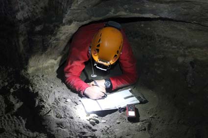
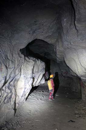
Underground survey - Exploration of medieval galleries - "Great Saule" Mine (Warndt) @ Photograph ERMINA
« Evolution der Bergbau- und Metallogische Technik und der Kulturlandschaft : der Warndt »
Le Warndt (Moselle) constitue une entité géologique originale localisé à la fois en Lorraine et en Sarre, appartenant au massif vosgien. Les gisements de cuivre et de plomb argentifère qu’il contient ont généré une industrie minière et métallurgique dont l’origine remonte selon les dernières découvertes à l’Antiquité (voire à la Protohistoire). Le programme vise à réaliser un une cartographie archéologique des exploitations minières et des vestiges qui lui sont associées en vue d’études et de valorisations futures.
« Evolution der Bergbau- und Metallogische Technik und der Kulturlandschaft : der Warndt » tel est le thème de la problématique définie et débattue lors des deuxièmes rencontres sur les mines anciennes du Warndt qui se sont tenues à Wallerfangen en Allemagne le 26 novembre 2016. Au total une vingtaine de chercheurs, enseignants chercheurs et étudiants des Universités de Lorraine et d’Allemagne ont participé à cette manifestation avec, à l’ordre du jour, la préparation d’un programme transfrontalier de recherches diachroniques sur ce patrimoine archéologique minier commun et dont l’importance dans le champ de l’archéologie des techniques a été plébiscité. Il y a différentes façons d’aborder la question de l’origine d’une activité minière/métallurgique. La première consiste à identifier et dater d’éventuels signaux de paléo-pollution recueillis à travers les sédiments après carottage et notamment dans les tourbières ; il est possible également de comparer certains éléments traces contenus dans les artefacts métalliques découverts et les minéralisations et ainsi de définir une origine de la matière première. Les prospections et les fouilles archéologiques constituent la manière la plus directe d’obtenir des informations, ce qui demande au préalable de réaliser un inventaire le plus détaillé possible des vestiges puis de sélectionner les sites à étudier.
Afin de dresser un inventaire des vestiges, une campagne de prospection LiDAR aéroportée du Warndt est envisagée pour le versant lorrain. Le versant allemand dispose déjà de telles informations. En revanche, la phase de traitement des données est toujours en cours. Une phase de mutualisation entre partenaires allemands et français sera donc nécessaire pour harmoniser les repérages.
“Evolution der Bergbau- und Metallogische Technik und der Kulturlandschaft: der Warndt”
The Warndt (Moselle) area is an original geological entity located both in Lorraine and Saarland, belonging to the Vosges massif. Copper and silver lead deposits contained in this area have generated a mining and metallurgical industry whose origin is dated from Antiquity or even Prehistory. The program will aim to carry out a full archaeological survey of the mining and associated remains for future studies and valuations.
“Evolution der Bergbau- und Metallogische Technik und der Kulturlandschaft der der Warndt" is the theme of the question defined and debated during the second meetings on the ancient Warndt mines held in Wallerfangen, Germany on 26 November 2016. Twenty researchers, lecturers and students from the Universities of Lorraine and Germany participated in this event, with the preparation of a cross-border program including diachronic research on this common mining archaeological heritage. Importance in the field of archaeology of technology has been highlighted.There are different ways to find the origin of a mining / metallurgical activity. The first one consists identifying and dating possible paleo-pollution signals collected through the sediments after coring particularly in peat bogs; It is also possible to compare trace elements contained both in metallic artefacts and mineralization and thus to define an origin of the raw material.
Archaeological surveys and excavations are the most direct way of obtaining information. This requires first a detailed inventory of the remains and a selection of the sites to be studied.
In order to inventory the remains, a prospective LiDAR airborne survey of the whole Warndt area is discussed for the Lorraine side. Such information is already available on the German side. On the other hand, the data processing phase is still in progress. A phase of mutualisation between German and French partners will therefore be necessary to harmonize the locations and establishment of a common MNT.
Archaeological Department Offices of Lorraine, Saarland and the Grand Duchy / MM the mayors of the communes of Falck / Hargarten aux Mines, Wallerfangen will be officially invited -
Some main lines of research on the Warndt mines to consider:
• historiography and archives researches
• LiDAR airborne survey and mapping - data evidence interpretation
• field surveys based on Lidar data - inventory archaeological sites
• peat bogs coring, sampling and dating
• Selection of archaeological sites
• Archaeological excavations (Mining sites but non only)
• perform chemical analyzes on artefacts.
• heritage preservation and/or enhancement. of sites and artefacts: scientific study, cultural mediation, experimental archaeology, ...